Roadtrip: Coopers Rock State Forest Fall Hike (part 2)
Don't forget to check out Part I.
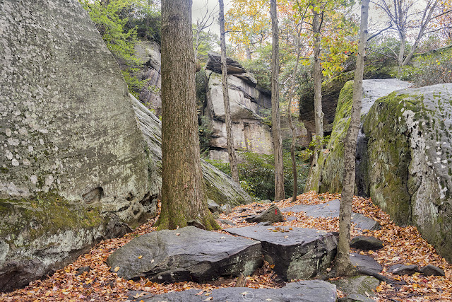
Per the park website, Underlook trail is 0.2 miles long and is rated as "moderate." I am guessing the rating is due to having to climb over a few boulders. I personally would rate it as "easy." The trailhead is easily spotted near the trailhead for Coopers Rock Overlook, and it takes you around the base of Coopers Rock. It is blazed red.
After you meander through the mini slot canyon, Rock City trail takes you through more forest. Bragging trees, showing off their brightly colored fall leaves, filled the woods, a last blessing before winter.
Like I had mentioned in my previous post, I decided to shorten my route due to the rain. Looking at the trail map, I decided to try to pick up Rattlesnake Trail from the parking lot and take it down to Rock City Trail, apparently an area with interesting boulders. There was only one problem, however -- I couldn't find Rattlesnake trail anywhere. I stumbled across some side trails which were perhaps remnants of no longer maintained routes, but couldn't locate the trailhead I was looking for.
 |
| This looked like it perhaps used to be a trail |
Instead, I saw signs for "Underlook Trail", which isn't labelled on the map (but is noted on the park website, now that I am looking). I decided to check out Underlook trail.
Turns out Underlook trail is pretty cool.
 |
| underneath the overlook |
Per the park website, Underlook trail is 0.2 miles long and is rated as "moderate." I am guessing the rating is due to having to climb over a few boulders. I personally would rate it as "easy." The trailhead is easily spotted near the trailhead for Coopers Rock Overlook, and it takes you around the base of Coopers Rock. It is blazed red.
It started to drizzle again, so I didn't take that many pictures in this section. However it did remind me of Ledges Trail in CVNP.
Somehow, almost astonishingly, I did end up finding Rattlesnake trail - it intersects with Underlook trail. Rattlesnake trail wanders through a predominantly rhododendron forest, taking you through and over some large boulders. It is blazed blue. It is 0.7 miles long, and connects to Rock City trail, my goal. Again, because of the intermittent rain, I didn't end up really taking pictures until I got to Rock City. Rock City is so named because of large boulders which create a long crevasse. You can crawl in and out of them - if you want. I kept thinking of Gorge Metropark.
Rock City is a 1 mile trail that connects back to the Coopers Rock parking area, sort of behind the gift shop. It is also blazed red. You can additionally take Rock City up to other trails, but I did not because I needed to drive home. Another day.
 |
| That's not a manmade wall |
Before you reach the road, you come across a very cute picnic shelter. There is also a restroom here.
Well, that's it! That was my mini adventure to West Virginia - I can't wait to go back to explore more of Coopers Rock State Forest.
Trail Details:
Length: Trails included on this page total to around 2 miles
Best time of year: Summer - Fall (note park access road is closed in winter)
Difficulty: Easy
Fees: None
Things to bring: Tick repellant, water, sunscreen
That's it! Keep on hiking, folks, and don't forget to subscribe and follow me here and here!


Comments
Post a Comment